Divide the County! The 1855 proposal and petition to divide Placer County

This article appeared in the May-June 2026 issue of the Colfax Cobblestones newsletter.

By Robin Yonash

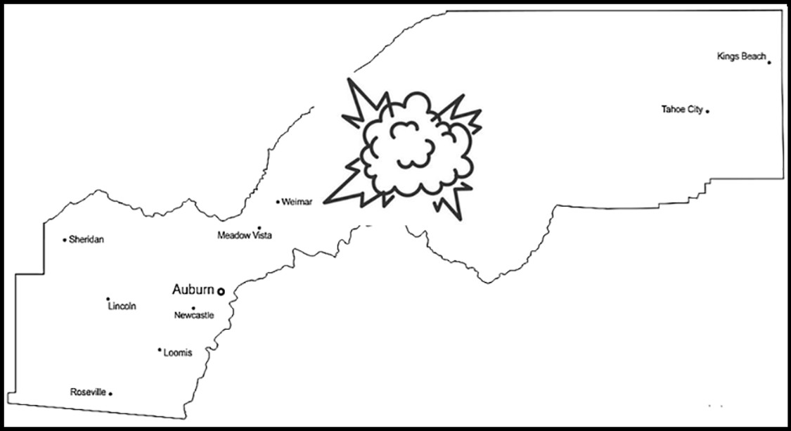
A writer signing himself XXX in the November 24, 1855, issue of the Iowa Hill News started a furor by proposing to divide Placer County, with Iowa Hill as the county seat of the new county. At the time, Placer had only been in existence since April 25, 1851—less than four years—formed from portions of Sutter and Yuba Counties with Auburn as the county seat.

The Iowa Hill News, owned by Olmstead and Miller, began publication in September 1855. Sadly, no copies remain, so the contents were extracted from quotes in other papers, mostly the Placer Herald.

“A Heavy Argument in favor of Division.—We will have a county seat nearer to us some day and then we will not be dependent upon the Auburn papers for the reports of the county officers,” XXX asserted.

This was not the first time for the proposal. The previous March, the Chico Weekly Chronicle-Record reported, “A Petition is in circulation in Placer county praying the Legislature to divide it into two counties,” but apparently it did not catch the public’s eye the way that XXX’s proposal did—possibly due to his hubris in naming Iowa Hill as the new county seat.

On the surface, the argument appears to have been based on the distance to travel to Auburn from the “Divide,” as the article went on to say, “The subject of a division of the county and the want of a new county seat of reasonable convenient access to a large portion of the people of Placer County, is exciting some attention among those who are most inconvenienced by the present arrangement.”

“Yankee Jims” scathingly responded on December 6th, claiming that a “certain Senator” (nameless) obtained his “unmerited” nomination from the Know Nothing party by pledging support for the division. He went on to say, “This present arrangement, I suppose, must inconvenience the proprietors of the News, to the extent of certain official patronage, which they snuff in the distance.”

He next countered with, “We now live in a county of some importance, some weight politically, say about the fourth in political magnitude in the State; as we now stand we can make ourselves felt in our legislative bodies, but divide us up, as three X’s propose, and we shall have two counties perhaps three, (for God knows where these things will stop once commenced), neither of which will support itself, or have the necessary weight in legislative matters.

In a December 8th editorial, Tabb Mitchell, Editor of the Placer Herald, also rebuffed the division proposal, saying “…the records show that the lower portion of the county pays two-thirds of all the money that goes into the County Treasury, and that two-thirds of the expenses of the criminal calendar, taking it for the last three years, has originated on the Divide,—they will oppose the measure, knowing full well as they do, that there is more security for them in the future, by remaining as they are, than trying the uncertainties of a petty county, assuming a heavy debt to start with, not a dollar in the treasury, nor public buildings of any kind—all of which would have to be built at a heavy expense, and for which still heavier taxes would have to be levied, and as a matter of course, the taxpayers to pay them.

At the time, the “Divide” was defined to include the towns of Iowa Hill, Yankee Jims, Michigan Bluff(s), Wisconsin Hill, Humbug, Todds Valley, Foresthill, and Last Chance.

Humbug, renamed Damascus in 1856, was located about 10 miles northeast of Iowa Hill on Humbug Canyon.

Last Chance was 7.5 miles northeast of Michigan Bluff.

Both Humbug and Last Chance are now ghost towns.

On December 15th, A.B.C. wrote in support of both counter-arguments. He also rejected the idea of easier access, saying, “It is just as convenient for us to go to Auburn as it would be to Iowa Hill. The present county seat is favorably situated in a central position for the whole county, and when occasion requires our attendance at it in the winter, we don’t have two or three feet of snow to contend with, as the case is at Iowa Hill.”

That same day, “Michigan Bluffs” argued that the legislative influence of the mining districts depends “very much upon the strength and unity” with the agricultural and the commercial delegations of the western part of the county.

Subsequent writers, one mockingly designating himself as “One X,” emphasized the costs of setting up a new county, and the ensuing burden on the taxpayers.

(The concern about how to pay the county debt was a valid one. On January 14, 1856, Senator Hawthorne introduced a bill in the State Legislature to fund the debt of Placer County. Instead, on March 11, 1856, the legislature passed a bill that allowed Placer County to impose a special tax to pay down its debt.)

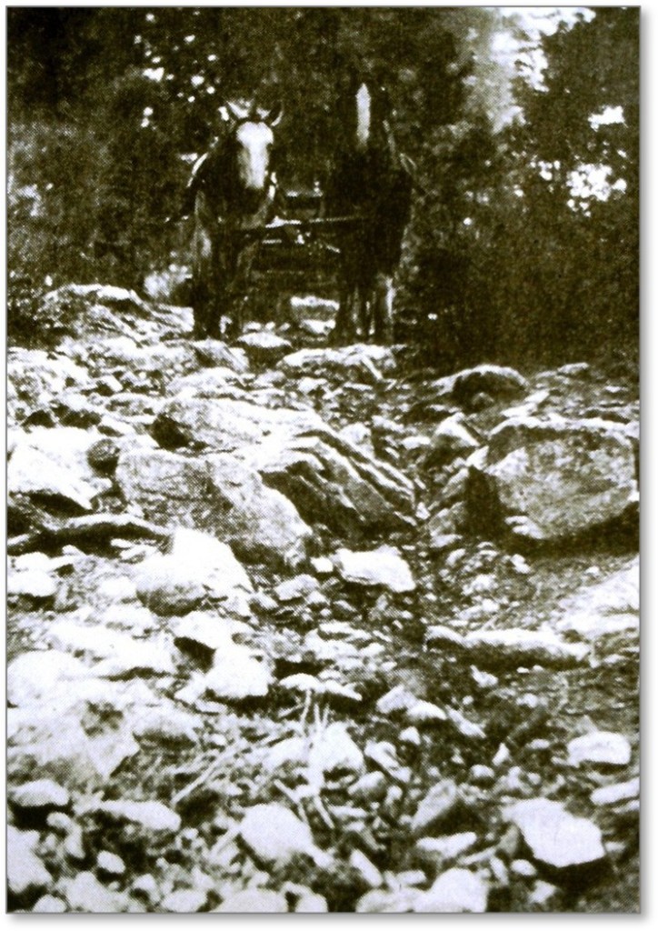
Strangely, the issue of transportation access to Iowa Hill vs Auburn was mostly not emphasized in the counter-arguments, even though that was the main reason put forth for the division in the first place. Iowa Hill was at least – if not more – as difficult to travel to as Auburn, especially during the winter. The photo on the next page shows the “road” across Shirttail Creek, which would have to be crossed to get from Yankee Jims to Iowa Hill, and this was in 1910 – 55 years later!

Another curiosity is that there was very little commentary authored by residents of south Placer.

Action began with a notice signed “Many Citizens” in the Iowa Hill News calling for a public meeting of the residents of the upper end of the county to be held at Herrick’s Hotel in Yankee Jims on the 29th of December, 1855, “for the purpose of devising measures to secure a division of the county, if that end should be deemed advisable.”

Samuel Todd, who was favorable to the division, was chosen as chairman and a committee was appointed to draft resolutions to be submitted to the meeting for action.

Then the meeting became fractious. During the absence of the committee, a gentleman from Iowa Hill moved for an adjournment, which passed after some discussion. The Placer Herald reported that “The gentlemen of the committee returning, found the body which had empowered them to draft resolutions, &c., and to which they were ready to report, dissolved. The explosion (of words) which took place at this juncture I will not attempt minutely to describe…”

Photo of the Road to Drummond Mine from Succor Flat across Shirttail Creek. Photo was taken about 1910, Iowa Hill.
The road to Drummond Mine from Succor Flat across Shirttail Creek. The photo was taken about 1910, Iowa Hill.

The delegates said that they had come to discuss “not so much the expediency, for that they considered settled, of a division of the county, as where the dividing line should be.” Col. McClure replied that he was opposed to any division of the county at the present time, and that this meeting had been surreptitiously called to “make it appear that the citizens of Yankee Jims were favorable to a division, when in fact they were opposed to such a measure.”

William Duck, Esq., proposed to change the discussion to the expediency of a division, which was agreed to. Col. Wm. McClure proposed a resolution, that a Convention of the citizens of the Divide be held on January 12th at Wisconsin Hill, and that delegates be chosen for every election precinct in proportion to the number of votes polled at the last general election. This resolution was unanimously adopted.

The delegates duly met on January 12th in Wisconsin Hill: Iowa Hill 9 votes. Wisconsin [Hill] 3, Yankee Jims 4, Todd Valley 3, Foresthill 2, Smith’s Ranch 1, Mineral Bar 1, Ford’s Bar 2, Green Valley 2; total 27. Thos. P. Slade, Esq., was appointed Chairman, and M. M. Robinson, Secretary.

The motion to divide the County won by 17 to 10 and a committee was appointed to settle the boundary line of said county.

The Chico Weekly Chronicle-Record duly reported that “Interested parties are agitating the erection of three new counties by the Legislature. …; another is to be formed of the upper portions of Placer, …”

On February 25, 1856, a writer signing himself as Washington County. (Defunct.) wrote, “To show you how near we have come to a division of Placer county, I will say that each and all of the above named places [on the Divide] will vote for a division if they can have the new county line run in such a manner as to have the center of said county concentrate at their own locality; to accomplish which, beats the oldest man in the mountains.”

The last mention found in the press was by the Chico Weekly Chronicle-Record on March 10, 1855: “A Petition is in circulation in Placer county praying the Legislature to divide it into two counties.” Apparently, not enough signatures were acquired and the proposal died.

Thank goodness it did, because between 1899 and 1910, gold production in Placer County showed a precipitous decline, from about $1,000,000 annually to around a quarter of that.  No definitive reason could be found for why so many mines closed, but because they did, the new county—had it happened—would have no doubt been pleading to rejoin its other half.

Author’s note: this article is an expansion of the topic mentioned briefly in my book The Iowa Hill Divide Volume 3—Gold and Fire: A History of the Iowa Hill Divide. It and my other two books, The Iowa Hill Divide Volume 1: Schools of the Iowa Hill Divide, 2nd Ed. and The Iowa Hill Divide Volume 2: Towns and People of the Iowa Hill Divide are available for purchase at the Colfax Heritage Museum. Proceeds support the Colfax Area Historical Society.

Colfax at 160 Years

Celebrating Railroad Changes and Incidents That Redefined the Region

We hope you will join us for a great presentation about Colfax and some of the changes over the past 160 years — since the town was created by the railroad in 1865.

Saturday, October 11, 2025 at 4 pm
in the Colfax Passenger Depot
99 Railroad St, Colfax, California

Roger Staab prepared this program for the Placer Sierra Railroad Heritage Society and in honor of Colfax’s 160-year link to the transcontinental railroad.

The 1923 Fire that Threatened the TB Sanatoria

The October issue of Colfax Cobblestones includes the story of the forest fire that threatened the TB Sanatoria in Colfax 102 years ago, in 1923.

This story was originally printed in the Tea Bee magazine, Vol. 11, No. 9, October 1923, which was published by the Colfax School for the Tuberculous in Colfax, California. It was transcribed by Roger Staab.

The October issue also includes information about our October 11 presentation and a timeline about the history of Colfax from 1849-2007.

The 1930 Fire in Downtown Colfax

The Lobner Building and other businesses on Main Street, Colfax, California, circa 1900. The Lobner Building is the two-story building in the center of the photo. This photo was taken about 1900.

Ninety-five years ago, a morning fire in downtown Colfax, California destroyed a café and a barber shop before it was put out. The Lobner Building caught fire twice but was saved. The fire train that Southern Pacific quickly brought to the Grass Valley Street crossing to help the Colfax fire department was crucial to saving downtown.

The July 2025 issue of the Colfax Cobblestones newsletter includes the story as originally reported in the Colfax Record and Sentinel, on June 20, 1930. The fire itself occurred on June 18, 1930.

Roger Staab transcribed the article from the original publication. This story also appeared in the June 2025 issue of the Placer-Sierra Railroad Heritage Society newsletter.

April 5, 2025, presentation: The Colfax Fireballs – Decades of Fast-pitch Softball

Updated location: Mike Ray’s presentation will now be at Colfax City Hall, 33 S Main St, Colfax, California.

Join us Saturday, April 5, 2025, at 4 p.m. for stories, photos, memorabilia, and a film about the Colfax Fireballs, a baseball team that represented Colfax, California, from 1947-1993.

There is no charge to attend. Everyone is welcome.

The Colfax Fireballs’s fans turned out for the 1982 ASA (Amateur Softball Association) state tournament held at the Colfax Living War Memorial Park, Colfax, California.

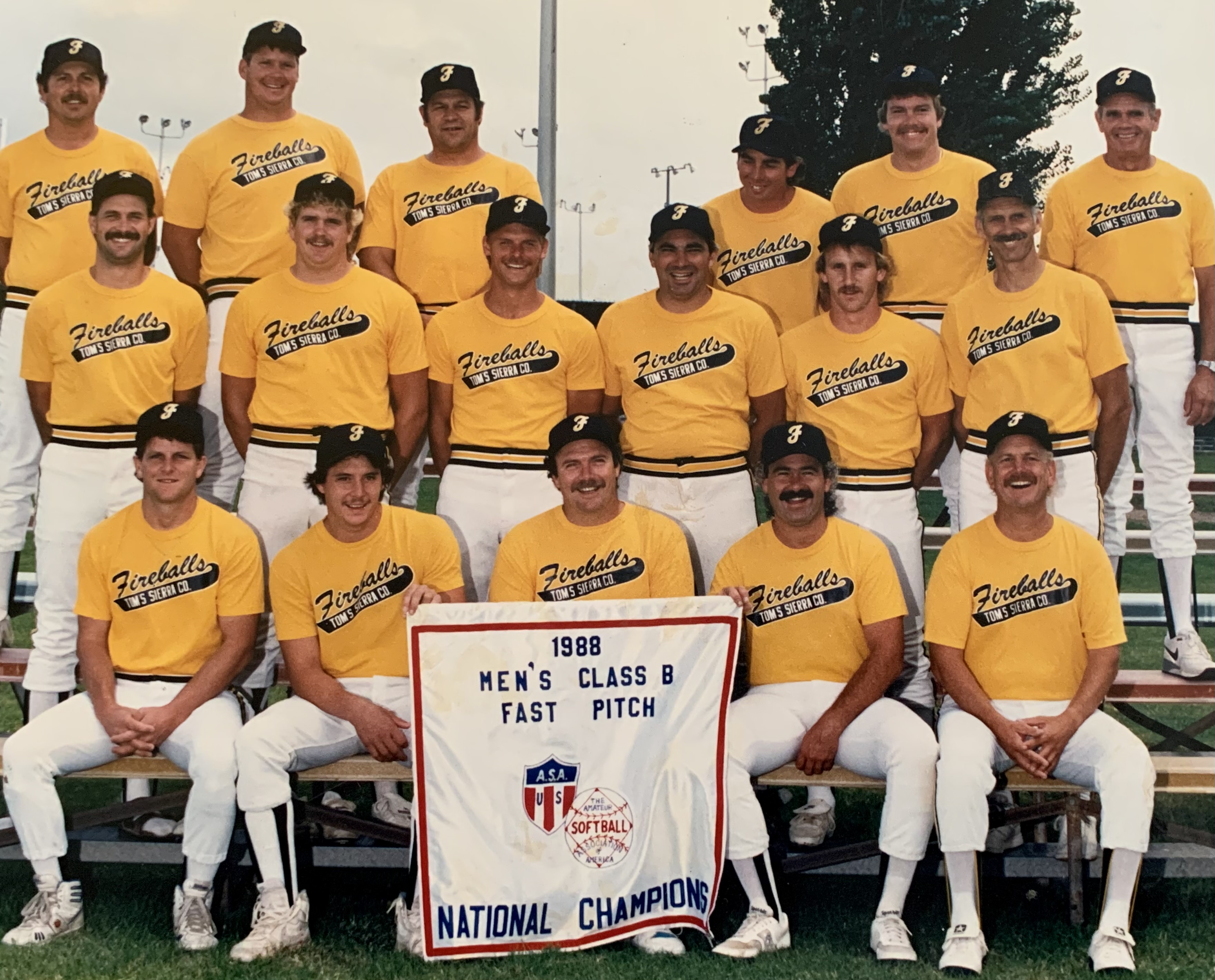
Mike Ray, former sports editor of the Grass Valley Union and the Colfax Record, will display memorabilia and tell stories about the Colfax Fireballs. The team began as a hardball team in 1947 and switched to fast-pitch softball in 1956. The Fireballs competed against teams from Reno, Tahoe City, Grass Valley, Santa Rosa, Chico, Monterey, Pacific Grove, and other Northern California cities.

The Colfax Fireballs, 1977.

Beginning in 1966, the Colfax Fireballs hosted an annual fast-pitch tournament that continued until 2014. It began small, as part of a Recreation Day sponsored by the Colfax Recreation Department, which included activities at the swimming pool, games, softball, and a Saturday night dance.

The Colfax Fireballs at the ASA Nationals, Las Cruces, New Mexico, 1988.

The annual tournament would begin on Thursday or Friday and continue through Sunday. Over the years the number of teams in the tournament ranged from four to as many as 22.

Myrtle Findley’s scrapbook of letters from WW II servicemen

The April 2025 Colfax Cobblestones newsletter contains a short article about the letters that Myrtle Findley received from servicemen during WW II. During the war, Myrtle wrote letters to U. S. servicemen throughout the United States, Canada, Europe, and North Africa. She donated a scrapbook of the letters that she received from them to the Colfax Area Historical Society. It contains letters that she received from 1943-1944. The scrapbook is in the Archives Room of the historical society.

Read some of Myrtle Findley’s collection of letters from WW II servicemen

Benhard’s of Colfax in the 1940s was famous for its road information bulletins

Its delicious food became famous after the Benhards began publishing the Benhard Road Information Bulletin, which they distributed through service stations.

A black and white photo of Benhard's restaurant in Colfax, California, in the 1940s. Its outdoor signs say "Benhards -- delicious food" and "It's Cool Inside."
Benhard’s restaurant, Colfax, California, 1940s. All photos courtesy of American Restaurant Magazine, December 1949.

Benhard’s restaurant in Colfax was famous in the 1940s for two things: its delicious food and its mimeographed Road Information Bulletins that were distributed throughout the western states. The bulletins provided road information about U.S. Routes 40 and 30, describing road conditions across the United States from California to Pennsylvania, New Jersey, and New York.

The front of Benhard's business card.
The front of Benhard’s business card.

Each issue of the bulletin “gave the motorist what he wanted and needed first,” according to an article about Benhard’s that was published in the American Restaurant Magazine, December 1949.

Each issue began with a short overview of the cross-country driving conditions, and then it went “into great detail telling exactly what road conditions” were, identifying detours and possible rough spots, and calling attention to road stops that had “most of the facilities of civilization.”

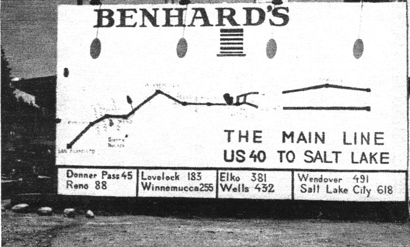
A billboard for Benhard’s restaurant, Colfax, California, 1949, showing distances from Benhard’s to cities in Nevada and Utah on U.S. Route 40.

For example, the bulletin for October 20, 1949, contained

“…a report on highway deaths and the causes for the fatal accidents; correct information on the exact amount of snow in the Sierra Nevadas; a detailed report on the conditions of the highway; a list of service stations operating 24 hours a day; traffic comparisons on various highways to California; a warning of a speed limit reduction on the Golden Gate bridge; news of a safer entrance into San Francisco; an ‘editorial’ on courteous driving; a few other items of motorist interest; … and then, and not till them, a message about some of the foods people drive miles to Benhard’s to enjoy.”

In 1945, Mr. and Mrs. F. H. Benhard opened their restaurant two blocks from Highway 40. They had to compete with three restaurants located next to the highway. Mr. Benhard told the American Restaurant Magazine that “the motorists felt our competitors served good food, too, and they did.

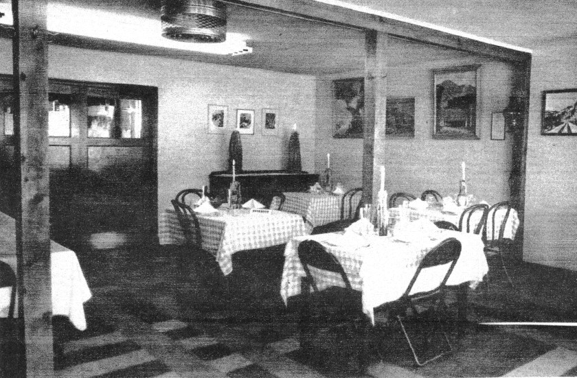
The interior of Benhard's restaurant, Colfax, California, 1940s. The dining room contains square dining tables, covered with checkered table cloths.
The interior of Benhard’s restaurant, Colfax, California, 1940s.

“That left us with one dream and one restaurant and about one customer.” One of their competitors had received “considerable publicity from a newspaper column” and some of the competitors been recognized by one of the eating guides. At the same time, the Benhards saw that there was

“considerable room for improvement of road information on Route 40; road information that was up to the minute; road information that would tell the motorist exactly what to look for as he wheeled through the mountains eastward or toward San Francisco. The Benhards made an experiment—did a little prospecting, and they struck gold. They began the series of Benhard Road Information Bulletins—simple, mimeographed sheets, which they distributed through dependable service stations on the Overland Route (30 and 40) in the states of Nebraska, Wyoming, and Nevada.”

Grateful drivers visited the restaurant “by the thousands.” The bulletin’s success brought so many people to Benhard’s restaurant that the couple who owned it were able to move to a new location on highway 40.

The back of Benhard's business card, showing distances from Benhard's to cities in California, Nevada, Utah, and Wyoming,
The back of Benhard’s business card, showing distances from Benhard’s to cities in California, Nevada, Utah, and Wyoming,

Note: So far, we haven’t been able to figure out where either of Benhard’s two locations were in Colfax. The first was several blocks away from Route 40; the second was on Route 40. If you know anything about Benhard’s history or where it was located, please leave a comment below or send us an email at museum@colfaxhistory.org

Where is U.S. Route 40?

U.S. Route 40 is a major east-west highway connecting Utah, Colorado, Kansas, Missouri, Illinois, Indiana, Ohio, West Virginia, Pennsylvania, Maryland, Delaware, and New Jersey. Originally its western terminus was San Francisco, California, but the construction if I-80 replaced the California to Utah section of Route 40. Route 40 itself replaced two older highways: the eastern National Road that was created by Congress in 1806 and ran from Maryland to Illinois, and the Victory Highway that was a memorial to WWI veterans and ran from Kansas City to San Francisco. (See “U.S. Route 40,” Wikipedia.)

Nighttime photos of downtown Colfax in the 1950s

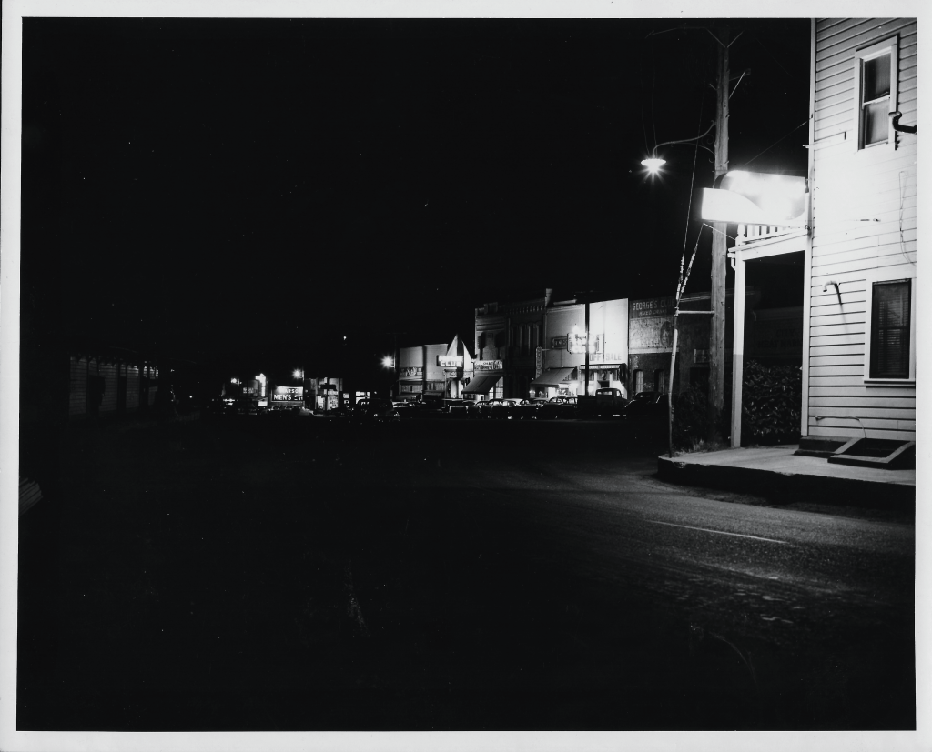
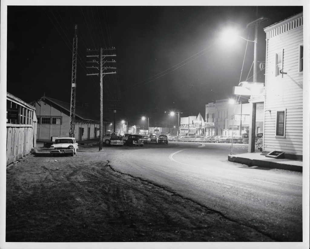
Three photos of downtown Colfax, California, from the 1950s got some attention on our Facebook page this week. The nighttime photos were taken by L. R. Farrell, Grass Valley, California. Copies of the photos were donated to the historical society in 1999.

Read about each photo and download high-resolution copies.

October 21st presentation is canceled

The October 21, 2023, presentation has been canceled.

Attendance at the quarterly presentations has dwindled since we restarted the presentations after COVID.

The board has decided to switch to one presentation in the summer, with a speaker that will draw a large crowd. It will be held in a larger, more comfortable location that will allow as many people to attend as are interested.

We will be planning an event such as the one we held in October 2019, with Robert S. Wells, author of Voices from the Bottom of the South China Sea, which was held in the City Council Chambers of the Colfax City Hall.

Robert S. Wells, author of Voices from the Bottom of the South China Sea, spoke in a special presentation, which was held in the City Council Chambers of the Colfax City Hall, October 20, 2019.

If you have any suggestions for speakers/authors or comments about this change, we would love to hear from you in an email to museum@colfaxhistory.org (you can also click the Contact Us link at the top of the page to send us your comments).